Agung Volcano Unrest Information
- Dr. Janine Krippner
I am NOT giving my own interpretations of the data and what the data means. I am NOT, and CANNOT tell people what this volcano might or might not do. Please always refer to all official source links below. The utmost respect must be given to the local authorities monitoring Agung.
I am not in Bali, nor am I an authority on Agung Volcano. I have not worked on Agung volcano, or any Indonesian volcano for that matter. Always look to the official sources for information, or to verify any information.
Official sources of information:
Twitter: Magma Indonesia, Sutopo Purwo Nugroho, BNPB Indonesia, PVMBG-CVGHM
Websites: Magma Indonesia Website, BNPB website, ESDM Website
Facebook: BNPB
I have been getting a lot of questions from travelers who are in, or planning on being in, Bali. Many travelers don't know where to get official information, cannot read it as it is in Indonesian, and do not, understandably, understand what it means. So, right now I am a volcanology translator to try and get good (official) information out there on the Agung situation so that people can access it.
This page is to direct you to the official information sources and websites that explain the primary volcanic hazards that have been stated to be present at Agung. Scroll down the page for links to the hazard maps. You will need to right click on the Indonesian pages and select 'translate', but be wary as translations can be pretty bad in places. 'Smoke' has so far meant gas/steam, not ash.
Also take note of my latest post: Agung is erupting - Now what?
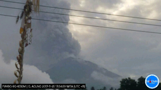
Agung is still experiencing eruptive activity and is on Alert Level 3 out of 4. The danger area is within a 4 km radius around the crater. Listen to all information, advice, and warnings from the official sources linked to on this page. Activity can fluctuate at any time.
Agung has experienced a small phreatic eruption on 25 November 2017 at 17:30.
Locals are urged to stay calm, be prepared for ashfall in case the situation changes, follow official advice.
Agung has experienced a small phreatic eruption on 21 November 2017 at 17:05.
Locals are urged to stay calm, be prepared for ashfall in case the situation changes, follow official advice.
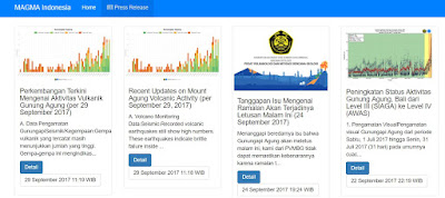
Please go to MAGMA Indonesia for the most up-to-date and official information. This is the authoritative source of information and updates on Agung volcano.
---
Primary source of updated official information: MAGMA Indonesia - there is also a MAGMA Indonesia app (I am not sure if it is available for iphones, I only have an android) where updates are sent to. It is in Indonesian, though, and not easy to translate.

MAGMA Indonesia has now included a live Seismogram.
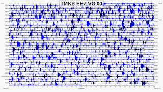 There is some basic information on how to read seismograms that was put together by IRIS here and a video by USGS here. Please keep in mind that people get entire advanced degrees on seismology and years of experience to fully understand these. You can gain some basic information on these graphs, but don't read too much into it. I will not be posting any of my own interpretations as first of all, I am not an authority monitoring Agung, and secondly, I have no formal education or experience in seismology.
VONA (Volcano Observatory Notice for Aviation) reports give notice of the status of the volcano when it changes. It is currently on ORANGE (but this changes regularly) to reflect the high level of activity. It has been on Yellow Alert more recently.
Kementerian Energi dan Sumber Daya Mineral, Badan Geologi (Ministry of Energy and Mineral Resources, Geological Agency)

BNPB - Badan Nasional Penanggulangan Bencana (National Board for Disaster Management)

Sutopo Purwo Nugroho works for the BNPB and is working to dispel rumors and also posts information on twitter.
The emergency radio station given by BNPB is: 146.800 MHz.
I have been getting a lot of questions along the lines of 'should I cancel my trip to Bali?'
I cannot give advice on what individuals should do - this is absolutely not my place.
However, if you are planning on going to Bali, or are already there, these are some recommendations but this is not a complete list:
- Advice on what to do was published by the Tribun Bali here.
- Check your travel insurance. Does it cover canceled flights or health issues if you end up in a bad situation?
- Check your country's official government travel advice, this should be on a Government or Embassy site. Many have a website dedicated to this and have addressed this situation. Some sites for: USA, New Zealand, Australia, UK, Singapore. The UK Embassy in Indonesia also has a Twitter account.
- Check with your airline.
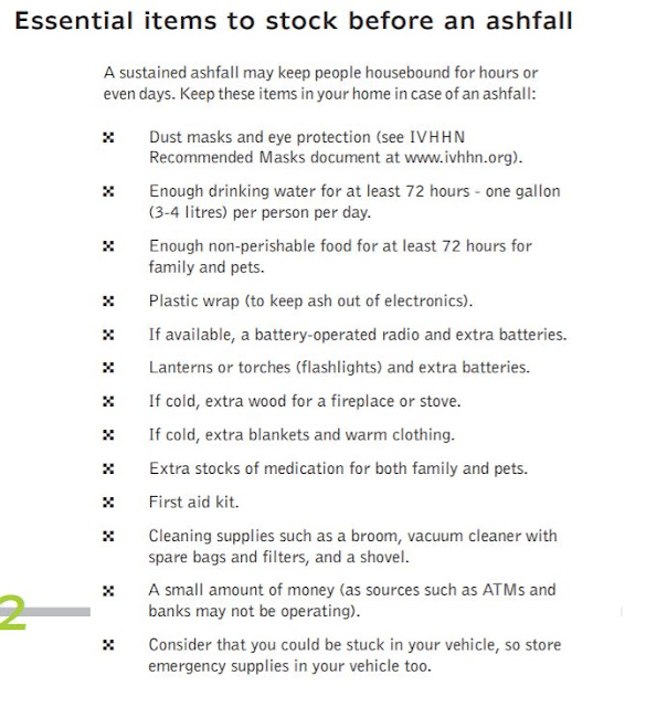
- Be prepared for ash fall. Volcanic ash is sharp pulverized rock, glass, and crystals. It is bad for your eyes, skin, and respiratory systems. Advice on how to prepare (in several languages) can be found here: The International Volcanic Health Hazard Network This includes what to take with you to keep safe in any ashfall that might occur.
Supplies such as face masks and eye protection have been periodically running out in Bali so take items like that with you.

The Bali tourism board released an official statement at 18:00 Bali time on 24 September.
OFFICIAL STATEMENT
Nomor : 956/GIPIBALI-BTB/K-IX/2017
Bali Tourism Board notes the increased frequency of Bali Airport coordination meetings between airline companies and all related airport authorities.
Reported during these airport meetings is the latest satelite image of Mount Agung and so far, as of this afternoon, the image shows no detection of volcanic ash. Intense monitoring continues for the Volcano Observatory Notice for Aviation and in coordination with the VA Advisory Darwin, Australia.
Bali Airport, I Gusti Ngurah Rai International, is operating as normal. Airline activities around Bali airspace are still normal with
passengers' arrival departure process maintained and no record of rushed departure of tourists.
Ferries and fast boats between Bali and neighbouring islands of Lombok and Java are also running their typical schedules.
For tour operators and travel agents who receive concerned queries from potential Bali visitors regarding the current situation of Mount Agung may check the latest update on the official website
www.BaliTourismBoard.or.id
specific page Crisis Center
On the foothill of Mount Agung, evacuees continue to seek shelter at the designated areas allocated by the government. Basic needs such as food and water are flowing in from all around Bali with volunteers supporting the distribution process.
As Mount Agung evacuees continue to pour onto shelters, Bali Tourism Board is directing assigned tourism professionals to support the coordination of timely delivery of donations from companies to the needy.
Denpasar, 24 September 2017 at 18:00 local Bali time.
Bali Tourism Board
Ida Bagus Agung Partha Adnyana
Chairman

See section near the top of the page for ashfall information.
Here is where you can find an interactive map with the danger zones. You can zoom in and make sure you are not in them! Stay out of the danger zones, they are based on where the most dangerous and deadly products that Agung may produce can go.
If you can't get the interactive map to work, there is a high resolution image of the hazard map (without the current radial exclusion zones indicated) here.
Two published, peer-reviewed papers on Agung:
A summary of Agung volcano, it's eruption history, and activity summaries are available at the Smithsonian Global Volcanism Report site.

Karen Fontijn has put together a summary of the previous activity at Agung volcano, and what monitoring was available at that time. In case there are issues viewing this, I have pasted the contents at the bottom of this page. This discusses the long history of volcanic eruptions at Gunung Agung, Bali.
Below is a translation of a Tribun Bali interview with Surono. I had a lot of help from Bambang Ardayanto, who did most of the work. This interview is important as it shows the levels of uncertainty the scientists and government officials are dealing with.
When the news regarding volcanoes at Indonesia are going widespread, Mr Surono become one of the people who people are looking for and asking him for his analysis and getting his opinion.
That is understandable since Mr Surono (62) is an expert of volcanology and geophysics in Indonesia. Grandpa Rono, what he is called in Indonesia, was very popular during the Merapi, near Yogyakarta city, eruption in 2010. During that time, he was the Chief of PVMBG (Pusat Vulkanologi dan Mitigasi Bencana Geologi) or Center of Volcanology and Mitigation of Geology Disaster.
Mr Rono, a graduate of University of Savoei, Chambery, France, was on Sunday (24/9/2017) in Bali, and accompanied the team from the Ministry of Maritime Coordination even visiting refugees at the camp at Tanah Ampo, Karangasem.
During his visit, Tribune Bali interviewed Mr Rono regarding the increase of Mt Agung activity.The translation of his interview is as follows:
Tribun Bali (TB):
If Mt Agung erupts, how powerful might the explosion be according to your opinion?
Surono (S):
If we refer to the 1963 eruption, it could be same. But it can also differ. Maybe lower, maybe greater or maybe no explosion?
TB: Why might there be no explosion?
S: Because we cannot rely on the tremor frequency only. If there is frequent tremor and all of the gas is released from the magma, it will not produce an explosion. We can't predict based on tremor activity and then make an explosion or eruption power prediction. Tremors or volcanic earthquakes are a sign of the high level of volcanic activity. This level of activity can't be used as a reference to predict a big eruption, even if the level of volcanic earthquakes and volcano activity inside the crater increases.
TB: from the monitoring signals of the activity at Mt Agung that you have observed, can we conclude if and when Mt Agung will explode or erupt?
S: No, we cannot. It should be understood that warning alert levels like Warning (Awas - the current level), Watch, Advisory, or Normal, are not to predict when the big eruption will come and how powerful the eruption will be. Although the volcano activity is increasing, people cannot judge if it will lead to an actual eruption. So, if the magma starts rising up, does it mean the eruption will occur? No. We don't know.
TB: It may have no eruption, can you explain?
S: It may only produce lava. It is like an eruption but not an explosion.
TB: if there is an explosion, what are the impact levels?
S: At least the direct impacts should not pass the radius of 9 km and the extended sector 12 km from the mountain. This zone has been announced by the government.
So the people within this dangerous area must be evacuated. Don't make assumptions, because if we make a wrong assumption, it is real mistake, and if you're right maybe it’s only just luck.
The next page;
TB: Compared to the Agung eruption of 1963, it was stated that the power of the eruption was 10 times higher than the Mt Merapi eruption in 2010. Is this right? What is the probability of the eruption power of Mt Agung if it erupts or explodes?
S: It may higher than Merapi, it may lower, or it might not erupt at all. Look at Merapi, it can have larger eruptions than before. If Mt Agung explodes like it did before, the people removed from exclusion zone within 9 km to 12 km from the mountain will be safe. If people have moved according to the recommendations they should be safe.
TB: How hot in degrees Celsius can the magma and the lava that move up Mt Agung get?
S: It may around 1000 to 1300 degrees Celsius for the molten lava. It will move and then cool to a lower temperature.
TB: about Mt Agung, what is the magma composed of?
S: About the same as at other volcanoes, Sulphur, CO2, Silica etc.
TB: What about the gas inside the magma?
S: If we talk about gas, most any volcano has this. Because of the change from the hot temperature to lower or cooler, the yield of this process is gas output. Magma mixed with Sulphur gas, CO2 and others.
---
30/09/2017
A long history of volcanic eruptions at Gunung Agung, Bali
Karen Fontijn, Post-Doctoral Research Associate
Department of Earth Sciences, University of Oxford
Email, Twitter: @VolcKaren
Recent signs of activity at Mt Agung, a volcano in Eastern Bali, are causing lots of concern to local populations and authorities, as well as tourists visiting the Indonesian island. This briefing note is intended to provide an objective summary of what we know about the volcano’s past history, and is based on scientific studies that have been published in international scientific journals.
Up until September 2017, Agung volcano was most famously known in the volcanology community for its 1963 eruption. This was a large explosive event, which caused more than 1100 fatalities among the communities living on the lower slopes of the volcano. The 1963 eruption was preceded by at least a few days of felt earthquakes before a lava flow was erupted from the summit crater, flowing down the northern flank of the volcano. This was then followed by a few weeks of minor explosive activity in the crater, after which an explosive eruption column sent large amounts of volcanic ash (small particle of rock debris) and gases more than 15 km up into the atmosphere. Another similar large explosive eruption followed two months later. Some of the volcanic ash fell back down to the northwest of the volcano and buried crops and roofs under a layer up to 50 cm thick. The eruption also caused hot mixtures of volcanic gases and rock debris (pyroclastic flows) to travel down the slopes of the volcano. Some of these pyroclastic flows turned into devastating mudflows (lahars) further down. It is these pyroclastic flows and lahars which caused most of the fatalities in 1963.
There was only little or even no instrumental monitoring done in 1963 – in those days the methods were not yet developed as they are today, and even volcanology as a science hardly existed. In the last few decades we have learnt a lot about how volcanoes work and our capacity to monitor volcanoes using a range of instruments has improved significantly. Today Indonesian and international volcanologists are using all this combined knowledge that we have acquired from studying volcanoes around the world to interpret the signs of unrest at Agung, and inform emergency managers. The hazard maps and evacuation zones that are currently in place around the volcano are largely based on what we know from Agung’s past eruptions, including the 1963 event.
The eruptive history of Agung was pieced together by studying the volcanic rocks that are found all around the volcano. Together with colleagues at the Indonesian Volcanological Survey (CVGHM) and the Earth Observatory of Singapore, we have been able to go 5000 years back in time and identify the typical style of activity at the volcano. Underneath the volcanic ash layer from the 1963 eruption, we find another 51 such ash layers from older volcanic eruptions. The oldest ash layer we found was about 5000 years old – we determined this age using radiocarbon dating. So that basically tells us that the volcano – on average – erupts about once every century. By comparing the thickness of the ash layers from the older eruptions with that of the 1963 eruption, we find that some eruptions were probably a bit smaller than 1963, others were of similar size. Everywhere in the valleys to the north-northeast and southwest-southeast we find rocks that were emplaced by pyroclastic flows and lahars, including in 1963, but also before that. This means that these same valleys are prone to similar phenomena in the future. Finally we also find a lot of lava flows on the upper slopes of the volcano. All this information together tells us that Agung has a repeated history of volcanic eruptions that are very similar in style to the 1963 eruption. We cannot know for sure whether every Agung eruption is always associated with volcanic ash fallout and pyroclastic flows and lahars and lava flows, but it is likely.
A large team of volcanologists will continue monitoring the situation and provide official updates on the activity on http://magma.vsi.esdm.go.id.
I am NOT giving my own interpretations of the data and what the data means. I am NOT, and CANNOT tell people what this volcano might or might not do. Please always refer to all official source links below. The utmost respect must be given to the local authorities monitoring Agung.
I am not in Bali, nor am I an authority on Agung Volcano. I have not worked on Agung volcano, or any Indonesian volcano for that matter. Always look to the official sources for information, or to verify any information.
Official sources of information:
Twitter: Magma Indonesia, Sutopo Purwo Nugroho, BNPB Indonesia, PVMBG-CVGHM
Websites: Magma Indonesia Website, BNPB website, ESDM Website
Facebook: BNPB
I have been getting a lot of questions from travelers who are in, or planning on being in, Bali. Many travelers don't know where to get official information, cannot read it as it is in Indonesian, and do not, understandably, understand what it means. So, right now I am a volcanology translator to try and get good (official) information out there on the Agung situation so that people can access it.
This page is to direct you to the official information sources and websites that explain the primary volcanic hazards that have been stated to be present at Agung. Scroll down the page for links to the hazard maps. You will need to right click on the Indonesian pages and select 'translate', but be wary as translations can be pretty bad in places. 'Smoke' has so far meant gas/steam, not ash.
Also take note of my latest post: Agung is erupting - Now what?

Most recent updates to this page (02 July 2018 USA date)
Agung is still experiencing eruptive activity and is on Alert Level 3 out of 4. The danger area is within a 4 km radius around the crater. Listen to all information, advice, and warnings from the official sources linked to on this page. Activity can fluctuate at any time.
Agung has experienced a small phreatic eruption on 25 November 2017 at 17:30.
Locals are urged to stay calm, be prepared for ashfall in case the situation changes, follow official advice.
Agung has experienced a small phreatic eruption on 21 November 2017 at 17:05.
Locals are urged to stay calm, be prepared for ashfall in case the situation changes, follow official advice.
---
OFFICIAL UPDATES
Please go to MAGMA Indonesia for the most up-to-date and official information. This is the authoritative source of information and updates on Agung volcano.
Click here for the 2 July 2018 press release - ballistic rocks ejected out to 2 km. (English summary)
---
--- PREPARING FOR POSSIBLE ASHFALL FROM AGUNG VOLCANO --
PVMPG (through the Tribun Bali) has recommended people be prepared for possible ashfall from Agung volcano.
Resource on volcanic ash
 |
| "Volcanic ash consists of tiny jagged pieces of rock and glass. Ash is hard, abrasive, mildly corrosive, conducts electricity when wet, and does not dissolve in water. Ash is spread over broad areas by wind." |
PVMPG reminds everyone that eruptions can not be predicted (time, size, etc), and which areas experience ashfall depends on the size of the eruption and the wind direction. Ashfall can reach across the island. The wind direction is currently (28.9.17) to the NW, but this does not rule out ash being directed to the east and south. The direction of an ash plume may be faster and thicker to the NW, while in other directions it may be thinner.
Information on ashfall including health, buildings, power, transportation, agriculture, and cleanup, can be found here: USGS Volcanic Ash Impacts & Mitigation.
Information pamphlets are available in English, Indonesian, French, Spanish, Portuguese, Japanese, Swahili, and Icelandic here: How to prepare and cope with ashfall.
Guidelines for facemasks are here: Information on Facemasks.
Ash information for children posters are also available at the bottom of this page.

Information on the effects of volcanic ash on children from one previous study:
Forbes L, Jarvis D, Potts J, et al., Volcanic ash and respiratory symptoms in children on the island of Montserrat, British West Indies. Occupational and Environmental Medicine 2003;60:207-211.
Ash information for children posters are also available at the bottom of this page.
Information on the effects of volcanic ash on children from one previous study:
Forbes L, Jarvis D, Potts J, et al., Volcanic ash and respiratory symptoms in children on the island of Montserrat, British West Indies. Occupational and Environmental Medicine 2003;60:207-211.
Please share this information. Some people are printing out the pamphlets to give to those who may not have access to this information. This is a great idea - take care of each other.
Unofficial travel advice
These two pages are not by official entities, but they may help answer some of your travel questions. These are two people who I have been in touch with who live in Bali:
Is it safe to travel to Bali with the volcano erupting? - By Theodora. Theodora has been updating this page as the status of the volcano changes.
Bali eruption advice: What to do! How to leave, how to skip and how to stay. - by Travelfish.org.
---
OFFICIAL SOURCES OF INFORMATION ON AGUNG ACTIVITY
Primary source of updated official information: MAGMA Indonesia - there is also a MAGMA Indonesia app (I am not sure if it is available for iphones, I only have an android) where updates are sent to. It is in Indonesian, though, and not easy to translate.
MAGMA Indonesia has now included a live Seismogram.
VONA (Volcano Observatory Notice for Aviation) reports give notice of the status of the volcano when it changes. It is currently on ORANGE (but this changes regularly) to reflect the high level of activity. It has been on Yellow Alert more recently.
The Darwin Volcanic Ash Advisory Center provides the same type of information as VONA above.
Kementerian Energi dan Sumber Daya Mineral, Badan Geologi (Ministry of Energy and Mineral Resources, Geological Agency)
BNPB - Badan Nasional Penanggulangan Bencana (National Board for Disaster Management)
Sutopo Purwo Nugroho works for the BNPB and is working to dispel rumors and also posts information on twitter.
The emergency radio station given by BNPB is: 146.800 MHz.
---
TRAVEL INFORMATION
I have been getting a lot of questions along the lines of 'should I cancel my trip to Bali?'
I cannot give advice on what individuals should do - this is absolutely not my place.
However, if you are planning on going to Bali, or are already there, these are some recommendations but this is not a complete list:
- Advice on what to do was published by the Tribun Bali here.
- Check your travel insurance. Does it cover canceled flights or health issues if you end up in a bad situation?
- Check your country's official government travel advice, this should be on a Government or Embassy site. Many have a website dedicated to this and have addressed this situation. Some sites for: USA, New Zealand, Australia, UK, Singapore. The UK Embassy in Indonesia also has a Twitter account.
- Check with your airline.
- Be prepared for ash fall. Volcanic ash is sharp pulverized rock, glass, and crystals. It is bad for your eyes, skin, and respiratory systems. Advice on how to prepare (in several languages) can be found here: The International Volcanic Health Hazard Network This includes what to take with you to keep safe in any ashfall that might occur.
Supplies such as face masks and eye protection have been periodically running out in Bali so take items like that with you.
---
The Bali tourism board released an official statement at 18:00 Bali time on 24 September.
OFFICIAL STATEMENT
Nomor : 956/GIPIBALI-BTB/K-IX/2017
Bali Tourism Board notes the increased frequency of Bali Airport coordination meetings between airline companies and all related airport authorities.
Reported during these airport meetings is the latest satelite image of Mount Agung and so far, as of this afternoon, the image shows no detection of volcanic ash. Intense monitoring continues for the Volcano Observatory Notice for Aviation and in coordination with the VA Advisory Darwin, Australia.
Bali Airport, I Gusti Ngurah Rai International, is operating as normal. Airline activities around Bali airspace are still normal with
passengers' arrival departure process maintained and no record of rushed departure of tourists.
Ferries and fast boats between Bali and neighbouring islands of Lombok and Java are also running their typical schedules.
For tour operators and travel agents who receive concerned queries from potential Bali visitors regarding the current situation of Mount Agung may check the latest update on the official website
www.BaliTourismBoard.or.id
specific page Crisis Center
On the foothill of Mount Agung, evacuees continue to seek shelter at the designated areas allocated by the government. Basic needs such as food and water are flowing in from all around Bali with volunteers supporting the distribution process.
As Mount Agung evacuees continue to pour onto shelters, Bali Tourism Board is directing assigned tourism professionals to support the coordination of timely delivery of donations from companies to the needy.
Denpasar, 24 September 2017 at 18:00 local Bali time.
Bali Tourism Board
Ida Bagus Agung Partha Adnyana
Chairman

---

---
The phone number below was posted for the Gunung Agung Disaster Relief Headquarters call center. This was posted on 25 September.

---
AGUNG VOLCANO HAZARDS
See section near the top of the page for ashfall information.
Here is where you can find an interactive map with the danger zones. You can zoom in and make sure you are not in them! Stay out of the danger zones, they are based on where the most dangerous and deadly products that Agung may produce can go.
 |
| Interactive hazard map, link above. |
If you can't get the interactive map to work, there is a high resolution image of the hazard map (without the current radial exclusion zones indicated) here.
 |
| Hazard map without the current radial exclusion zones. |
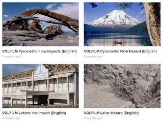
To learn more about the primary hazards - pyroclastic flows and lahars, go to VolFilm's Videos. These videos were specifically made by volcanologists to explain hazards and impacts of pyroclastic flows and lahars.
Pyroclastic flow and lahar hazards resource
---
AGUNG VOLCANO HISTORY AND GENERAL INFORMATION
Information on the history of Agung volcano
Two published, peer-reviewed papers on Agung:
A summary of Agung volcano, it's eruption history, and activity summaries are available at the Smithsonian Global Volcanism Report site.
Karen Fontijn has put together a summary of the previous activity at Agung volcano, and what monitoring was available at that time. In case there are issues viewing this, I have pasted the contents at the bottom of this page. This discusses the long history of volcanic eruptions at Gunung Agung, Bali.
---
Below is a translation of a Tribun Bali interview with Surono. I had a lot of help from Bambang Ardayanto, who did most of the work. This interview is important as it shows the levels of uncertainty the scientists and government officials are dealing with.
When the news regarding volcanoes at Indonesia are going widespread, Mr Surono become one of the people who people are looking for and asking him for his analysis and getting his opinion.
That is understandable since Mr Surono (62) is an expert of volcanology and geophysics in Indonesia. Grandpa Rono, what he is called in Indonesia, was very popular during the Merapi, near Yogyakarta city, eruption in 2010. During that time, he was the Chief of PVMBG (Pusat Vulkanologi dan Mitigasi Bencana Geologi) or Center of Volcanology and Mitigation of Geology Disaster.
Mr Rono, a graduate of University of Savoei, Chambery, France, was on Sunday (24/9/2017) in Bali, and accompanied the team from the Ministry of Maritime Coordination even visiting refugees at the camp at Tanah Ampo, Karangasem.
During his visit, Tribune Bali interviewed Mr Rono regarding the increase of Mt Agung activity.The translation of his interview is as follows:
Tribun Bali (TB):
If Mt Agung erupts, how powerful might the explosion be according to your opinion?
Surono (S):
If we refer to the 1963 eruption, it could be same. But it can also differ. Maybe lower, maybe greater or maybe no explosion?
TB: Why might there be no explosion?
S: Because we cannot rely on the tremor frequency only. If there is frequent tremor and all of the gas is released from the magma, it will not produce an explosion. We can't predict based on tremor activity and then make an explosion or eruption power prediction. Tremors or volcanic earthquakes are a sign of the high level of volcanic activity. This level of activity can't be used as a reference to predict a big eruption, even if the level of volcanic earthquakes and volcano activity inside the crater increases.
TB: from the monitoring signals of the activity at Mt Agung that you have observed, can we conclude if and when Mt Agung will explode or erupt?
S: No, we cannot. It should be understood that warning alert levels like Warning (Awas - the current level), Watch, Advisory, or Normal, are not to predict when the big eruption will come and how powerful the eruption will be. Although the volcano activity is increasing, people cannot judge if it will lead to an actual eruption. So, if the magma starts rising up, does it mean the eruption will occur? No. We don't know.
TB: It may have no eruption, can you explain?
S: It may only produce lava. It is like an eruption but not an explosion.
TB: if there is an explosion, what are the impact levels?
S: At least the direct impacts should not pass the radius of 9 km and the extended sector 12 km from the mountain. This zone has been announced by the government.
So the people within this dangerous area must be evacuated. Don't make assumptions, because if we make a wrong assumption, it is real mistake, and if you're right maybe it’s only just luck.
The next page;
TB: Compared to the Agung eruption of 1963, it was stated that the power of the eruption was 10 times higher than the Mt Merapi eruption in 2010. Is this right? What is the probability of the eruption power of Mt Agung if it erupts or explodes?
S: It may higher than Merapi, it may lower, or it might not erupt at all. Look at Merapi, it can have larger eruptions than before. If Mt Agung explodes like it did before, the people removed from exclusion zone within 9 km to 12 km from the mountain will be safe. If people have moved according to the recommendations they should be safe.
TB: How hot in degrees Celsius can the magma and the lava that move up Mt Agung get?
S: It may around 1000 to 1300 degrees Celsius for the molten lava. It will move and then cool to a lower temperature.
TB: about Mt Agung, what is the magma composed of?
S: About the same as at other volcanoes, Sulphur, CO2, Silica etc.
TB: What about the gas inside the magma?
S: If we talk about gas, most any volcano has this. Because of the change from the hot temperature to lower or cooler, the yield of this process is gas output. Magma mixed with Sulphur gas, CO2 and others.
---
30/09/2017
A long history of volcanic eruptions at Gunung Agung, Bali
Karen Fontijn, Post-Doctoral Research Associate
Department of Earth Sciences, University of Oxford
Email, Twitter: @VolcKaren
Recent signs of activity at Mt Agung, a volcano in Eastern Bali, are causing lots of concern to local populations and authorities, as well as tourists visiting the Indonesian island. This briefing note is intended to provide an objective summary of what we know about the volcano’s past history, and is based on scientific studies that have been published in international scientific journals.
Up until September 2017, Agung volcano was most famously known in the volcanology community for its 1963 eruption. This was a large explosive event, which caused more than 1100 fatalities among the communities living on the lower slopes of the volcano. The 1963 eruption was preceded by at least a few days of felt earthquakes before a lava flow was erupted from the summit crater, flowing down the northern flank of the volcano. This was then followed by a few weeks of minor explosive activity in the crater, after which an explosive eruption column sent large amounts of volcanic ash (small particle of rock debris) and gases more than 15 km up into the atmosphere. Another similar large explosive eruption followed two months later. Some of the volcanic ash fell back down to the northwest of the volcano and buried crops and roofs under a layer up to 50 cm thick. The eruption also caused hot mixtures of volcanic gases and rock debris (pyroclastic flows) to travel down the slopes of the volcano. Some of these pyroclastic flows turned into devastating mudflows (lahars) further down. It is these pyroclastic flows and lahars which caused most of the fatalities in 1963.
There was only little or even no instrumental monitoring done in 1963 – in those days the methods were not yet developed as they are today, and even volcanology as a science hardly existed. In the last few decades we have learnt a lot about how volcanoes work and our capacity to monitor volcanoes using a range of instruments has improved significantly. Today Indonesian and international volcanologists are using all this combined knowledge that we have acquired from studying volcanoes around the world to interpret the signs of unrest at Agung, and inform emergency managers. The hazard maps and evacuation zones that are currently in place around the volcano are largely based on what we know from Agung’s past eruptions, including the 1963 event.
The eruptive history of Agung was pieced together by studying the volcanic rocks that are found all around the volcano. Together with colleagues at the Indonesian Volcanological Survey (CVGHM) and the Earth Observatory of Singapore, we have been able to go 5000 years back in time and identify the typical style of activity at the volcano. Underneath the volcanic ash layer from the 1963 eruption, we find another 51 such ash layers from older volcanic eruptions. The oldest ash layer we found was about 5000 years old – we determined this age using radiocarbon dating. So that basically tells us that the volcano – on average – erupts about once every century. By comparing the thickness of the ash layers from the older eruptions with that of the 1963 eruption, we find that some eruptions were probably a bit smaller than 1963, others were of similar size. Everywhere in the valleys to the north-northeast and southwest-southeast we find rocks that were emplaced by pyroclastic flows and lahars, including in 1963, but also before that. This means that these same valleys are prone to similar phenomena in the future. Finally we also find a lot of lava flows on the upper slopes of the volcano. All this information together tells us that Agung has a repeated history of volcanic eruptions that are very similar in style to the 1963 eruption. We cannot know for sure whether every Agung eruption is always associated with volcanic ash fallout and pyroclastic flows and lahars and lava flows, but it is likely.
A large team of volcanologists will continue monitoring the situation and provide official updates on the activity on http://magma.vsi.esdm.go.id.